
Monday, September 4, 2000 - Carbon Cliff to Savanna
This day was rough riding from the start and really tested me. We slept in, and then we went shopping at the Iowa Welcome Center store. We returned to Colona for a late, tasty breakfast at Smokey's Maid-Rite. Although Maid-Rite was founded in 1926, it was my first time eating at one.

We had a good breakfast at Maid-Rite.
After eating too much, we drove back to the point of our fortuitous rendezvous the night before. I didn't get on the bike until after noon, and I immediately faced a headwind that would bedevil me all the way from the Quad Cities up to Savanna. More distressing, I needed to find a restroom as soon as I took my bike off the trunk rack. If the urge had hit me 15 minutes earlier, I could have used the one at the restaurant.
I had a bit of trouble following the GIT through this area. First, there was a conflict between the GIT cue sheet and my map only a mile from where I started the dayÆs ride. Even the cue sheet hedged with a note after the directions that suggested a different route shown by the authorÆs map (apparently my map was not the only one to show it this way). It turned out that both of our maps were wrong, but following the original cue sheet instructions (ignoring the note) got me through Carbon Cliff. In East Moline, the streets weren't marked well, either. The ōhighlightö of this portion of the trip was passing by the East Moline Correctional Facility. After a brief stretch of busy highway, I got on the Great River Trail. This trail was intermittent all the way up to Savanna, with the gaps filled by roads. My first checkpoint of the day was described as " East Moline/Hampton Park." I was worried about finding the park since it wasnÆt on my maps, especially after missing Caboose Park in Matteson several weeks earlier. I couldn't count on being able to go back and look for this one since it was far from home. Fortunately, I found it right on the Great River Trail next to Empire Park. More importantly, there were flush toilet facilities there, too.

This well-placed sign encouraged people not to pollute the river.
Feeling much better after my pit stop, I steered through Hampton Park around 1:30 PM. The Great River Trail ran close to IL 84 through the next few towns.

I followed the Great River Trail most of the day.
I think it was Port Byron where I had my scariest moment of the day. I was on the trail and saw it turn left on a side street. As I started to turn, a pickup truck was in my bike lane trying to turn right onto IL 84! @#$%& *!!! I ran up over the curb, always a dicey move, but I didnÆt fall. The guy in the pickup truck was grinning oddly--IÆm not sure exactly what that meant. I veered back onto the street and discovered that the lines I saw for the bike lane were actually ghost lines that had been painted over with black. Apparently, this street no longer had a separate lane marked for the trail. I wondered if the apparent un-designation had something to do with the Boub case (see the League of Illinois Bicyclists site for more details of this case, which has scared local municipalities away from designating bicycle routes). Even worse, I found myself committing one of my pet peeve bicycle crimes--riding the wrong way against traffic. I crossed over to the right side as soon as I could.

Port Byron's welcome sign had a fittingly nautical theme.

In Port Byron, I saw this pink bike along the Mississippi River Trail. The directional sign said it was still 40 miles to Savanna.
The trail continued through Cordova, where it went right up to the river.

This nifty new kiosk marked Cordova.
When that part of the trail ended, I took a big detour east, far past IL 84 to Meridosia Road. Although this was a nice, scenic road with gentle bends and a few hills, I was beginning to get really frustrated with the headwind. With 25-30 miles to go, it seemed that I wouldn't make it to Savanna by dark. Just south of Albany was a pleasant but brief trail through the Albany Mounds State Historic Site. I wished I had time to stop and explore there. The Great River Trail was well marked throughout Whiteside County, even the on-road detours.

Whiteside County had Grand Illinois Trail signs, unlike many other counties.
Northeast of Albany, I was supposed to turn left on Ufkin Road. An orange construction sign warned, " Road Closed." Ufkin was a gravel road that only cut a short hypotenuse anyway, so I went up a short hill to the next road, Kennedy, instead. It turned out that Kennedy (which Ufkin led to) was the road that was closed. The bridge over Cedar Creek was being rebuilt. I came to a stop and assessed the situation. The wood forms were in place for the concrete, and a plank walkway ran down either side. I could have turned around and found a way around it, but heck, I was tired. Since it was Labor Day, no one was working and no one else was around. Easy choice. I hoisted my bike over and around the barricades and walked it over the bridge on the planks. The bicycle advocate in me was amused to think that someone driving a car wouldn't have had this option.

This bridge on Kennedy Road was closed.
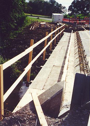
But this walkway made it easily passable on a bike.
Just south of East Clinton, the trail ran across the top of a levee. There was a great view up there. It was pretty neat I wish more of the Great River Trail ran along levees. I started singing Led Zeppelin's " When The Levee Breaks," especially when the trail ran down the side toward the flood plain. " Goin' down, goin' down now, goin' down, goin' down now..."

The trail ran atop the levee for a few miles.
I came to a fork in the trail in East Clinton. The GIT cue sheets directed me to the right. This was a very nice path that ran through a patch of woods on the eastern edge of town. Had it been a warmer day, I would have really appreciated the shade. Unbeknownst to me, the other fork went to the Fulton Windmill, a GIT checkpoint. I stopped at a gas station for Gatorade, orange juice and snacks, then continued north on the trail. I soon realized that I must have missed the windmill. I didn't want to turn back and waste precious daylight, so I decided that Fulton was close enough to Savanna that we could return by car to look for it at the end of the day.
North of Fulton, the path was rather remote. After many miles paralleling IL 84 a few yards away, this was a nice change. I was surprised when I saw others using the trail since it seemed to be in the middle of nowhere. The crushed stone trail emptied onto a beautiful pine tree-lined drive just south of Thomson. After skirting the west side of town, I had a good ride up Sandridge Road and Riverview Road. Eventually, I came back to IL 84 for the final ride into Savanna. Since it was getting dark quickly, I put a flashing taillight on my left rear pannier for visibility. I hoped it was enough, as traffic was fairly heavy. This was the price I paid for a leisurely late start. I was a little nervous for the first mile or two, but then a wide shoulder gave me some breathing room. As I came into town, I crossed a long bridge over railroad tracks. The Super 8 was impossible to miss atop the bluff. I gutted it out for one last steep climb to the motel, finishing with 59 miles at a slow 13.0 mph average (mostly due to wind). I finally made it to the Super 8 I had reserved for July 2, but two months late.
Since I needed to find the Fulton windmill and the dining options in Savanna were limited, we drove down to Clinton to eat. When we reached Fulton, I drove to the riverfront. The windmill was impossible to miss. The visitor center was closed, but I might have been too late even if I had found it the first time through town.

I had to return at night to find the Fulton windmill.
![]()
![]()
![]()
Copyright ® 2002-2013 David Johnsen. All rights reserved.